Location
States
CaliforniaEcosystem
Desert, River/stream, WetlandIntroduction
The Amargosa River is one of four river systems in the Mojave Desert, and runs from Nevada into the southern Death Valley region of California. The wetlands in the lower Amargosa River watershed were historically one of the most extensive in the Mojave Desert, but in the late 19th century large portions of wetland and riparian riparian
Definition of riparian habitat or riparian areas.
Learn more about riparian areas were drained and converted into agricultural areas. Alterations to hydrology from the construction of a railroad berm, development of springs for human recreation, and groundwater pumping have contributed to degradation and fragmentation of the remaining wetlands.
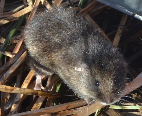
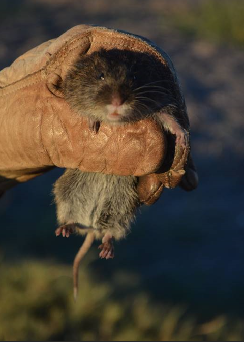
While the wetland is only a fraction of what it once was, it remains one of the most ecologically productive areas in the Mojave Desert and provides habitat for riparian birds, waterfowl, and invertebrates. The lower watershed supports a cottonwood-willow forest and several endemic and endangered species including the federal and California listed Amargosa vole. The Amargosa vole, an isolated subspecies of the California vole, is an endemic species that is one of the rarest mammals in North America and was thought to be extinct until the late 1970s. The Amargosa vole’s range is limited to the Amargosa River watershed and is entirely dependent on stands of wetland vegetation dominated by three-square bulrush, of which only an estimated 50-60 acres remain in the lower Amargosa River.
Key Issues Addressed
Groundwater pumping and land use conversion have resulted in significant wetland loss, and further degradation due to climate shifts and continued or expanded water use by humans will impact many species that depend on the ponds and vegetation of the Amargosa Valley. Managing the wetlands to maintain adequate water flow, however, is not a straightforward endeavor. Many local water sources are on private lands, and there are concerns that water diversion for wetlands will impact livelihoods. Development of urban areas, renewable energy projects, and climate shifts could reduce recharge of aquifers and springs that feed the lower Amargosa. Higher temperatures will result in higher evapotranspiration rates and greater potential for drying and eventual loss of wetland vegetation.
Scientific understanding of the Amargosa vole is essential for making challenging, potentially controversial management decisions for conservation of this species. This effort is intended to allow tracking of vole populations and prioritization of habitat conservation and restoration. These actions will help evaluate attempts to expand the vole’s distribution and population size while considering future environmental conditions.
Project Goals
- Collect basic information on Amargosa vole biology to support conservation and reintroduction efforts
- Combine monitoring and modeling to develop habitat and population projections for the future
- Foster relationships with local communities based on open communication about the shared benefits of conserving wetland and riparian areas
Project Highlights
- Population and Habitat Forecasting: Many studies were combined to create models of vole populations and habitat conditions. Study trials were used to determine diet needs and social interactions to inform reintroduction protocols. Mark-recapture trapping at 6 to 18 1-ha grids (108 traps per grid) as well as vegetation sampling at the trap stations were conducted simultaneously at approximately 6-week intervals from January 2012 to November 2016. In addition, Landsat satellite data on the Normalized Difference Vegetation Index (NDVI) were collected approximately bimonthly from January 1985 through December 2018. These highly integrated data have been used to derive estimates of the vole’s demography, monitor their population dynamics and the dynamics of wetland vegetation (e.g. production and productivity, changes in bulrush cover and extent), model the spatial (stochastic metapopulation models) and temporal dynamics (transient dynamics models) of the voles, conduct population viability analyses, and develop models to forecast the extent and condition of bulrush stands 25 to 50 years in the future.
- Determining Water Inputs: Water sources flowing from Tecopa Hot Springs and Tecopa into wetland and riparian areas were mapped from ground surveys to monitor input rates and determine the amounts that are critical for maintaining wetland vegetation.
- Captive Breeding Program: Because of the vole’s extremely limited range and small population size, a captive breeding program was started at UC Davis in 2012. Program goals are to: (1) learn about basic biology of the vole, and (2) develop programs for translocations as well as possible reintroduction into parts of their historic range that are currently unoccupied but where suitable habitat either still exists or can be restored.
- Amargosa Vole Distribution Efforts: Experimental vole translocations have been attempted. Voles from the captive breeding facility were placed in suitable but unoccupied patches of bulrush along the Amargosa River. The degree of success is being monitored by biologists.
- Habitat Restoration: Based on knowledge of habitat requirements, five acres of marsh at the northern limit of the wetlands were partially restored to increase bulrush and other wetland habitat for the Amargosa vole, pupfish, and multiple bird species. There are ongoing efforts to remove and control invasive tamarisk.
- Collaboration and Public Engagement: Annual town meetings are held among government agencies, local conservation groups, and Tecopa Hot Springs residents to keep the public informed of project activities and to address any questions or concerns. Public engagement and support are essential to long-term maintenance of habitat along the Amargosa River.
Lessons Learned
Habitat Specialists: Understanding that Amargosa voles are entirely dependent on bulrush within a restricted range allows managers to directly address conservation needs and prevent extinction.
A great degree of highly integrated science-driven management has led to the effectiveness of this project. This includes population and habitat monitoring, field and lab experiments on diet and social interactions, habitat restoration, captive breeding, and translocations. This allows the vole population and its habitat to be tracked, targets activities for areas where they will accomplish the most good, evaluates expanding the vole distribution, and plans for possible future environmental conditions.
Of particular significance has been the evolution of the project’s focus from vole conservation to a much broader perspective of managing the wetlands and recognizing that management activities of potential benefit to the vole may not benefit other wetland species with different habitat needs. The success of these activities is an outcome of effective collaboration among a diverse group of partners, including three federal agencies (U.S. Fish & Wildlife Service, Bureau of Land Management, U.S. Geological Survey), one state agency (California Department of Fish & Wildlife), two universities (University of California, Davis; University of California, Berkeley), and three non-governmental organizations (Amargosa Conservancy, Shoshone Village, and The Nature Conservancy).
Challenges to long-term conservation along the Amargosa River include socio-economic perceptions, long-term planning, and water management. The human population and economy in the lower Amargosa watershed are sparse; therefore, the region and its issues are sometimes seen as unimportant. Long-term planning is critical because the vole will always be a conservation-dependent taxon, but the desire for agencies to devote resources to manage the vole in perpetuity is not high. Most management activities have been targeted at short-term needs and serious discussions on longer term issues have not materialized. Finally, developing management strategies when the system has a considerable degree of natural variability makes setting appropriate objectives and measures of success difficult.
Additional findings include:
- The wetlands have very pronounced temporal and spatial dynamics, with approximately 20% of the area over a 30-year period undergoing often rapid transitions from bulrush to salt grass and vice-versa.
- In some cases, the areas transitioned back to their previous state, indicating the wetlands have some degree of resilience.
- Some of the transitions can be attributed to human activities (altered hydrology), but many others cannot.
- The recent drought (2012 - 2016) had a pronounced effect on the wetlands. Cover of bulrush decreased by 17% to 90% (mean=71%), while an index of vegetation (NVDI) production decreased by almost 75%.
- The vole population is closely tied to bulrush production; density increases in the spring as bulrush begins to green-up, peaking in the late summer when bulrush production also peaks.
- Degradation or further loss of wetland area will impact many species other than the vole that are dependent on the ponds and vegetation, especially birds such as waterfowl, wading birds, grebes, coots, and rails.
- Managing water supply to the wetlands is complicated by an interplay between local and regional hydrology, as well as a patchwork of public and private ownership of water sources.
Next Steps
- Secure agreements with the residents of Tecopa Hot Springs and Tecopa to maintain water flow into wetlands to benefit voles and their habitat along with many other species
- Integrate regional hydrologic flow models with data on vegetation dynamics, including measurements of evapotranspiration
- Model the relationship between vole carrying capacity and seasonal and interannual fluctuations in bulrush productivity
- Continue experimental translocations to try to expand vole distribution within the wetlands
Funding Partners
- U.S. Fish & Wildlife Service
- Bureau of Land Management
- California Department of Fish & Wildlife
- Amargosa Conservancy
- University of California, Davis
- University of California, Berkeley
Resources
- California Department of Fish and Wildlife Amargosa Vole Conservation Website
- U.S. Fish and Wildlife Service Amargosa Vole Species Profile
- Amargosa Conservancy Species Page
- New York Times Article: The Amargosa River Defies the Desert
- Foley et al. (2013). “Severe ulceronecrotic dermatitis associated with mite infestation in the critically endangered Amargosa vole (Microtus californicus scirpensis).” Journal of Parasitology 99 (4): 595-598.
- Foley, J., and Foley, P. (2016). “Rapid assessment and extinction prediction using stochastic modeling of the endangered Amargosa vole.” Wildlife Biology in Practice 12(1): 1-11.
- Izbicki, J. (2007). “Physical and temporal isolation of mountain headwater streams in the western Mojave Desert, southern California.” Journal of the American Water Resources Association 43(1): 26-40.
- Klinger et al. (2015). “Implications of scale-independent habitat specialization on persistence of a rare small mammal.” Global Ecology and Conservation 3: 100-114.
- Klinger et al. (2017). “The vole in the climatic coal mine: How one of the rarest mammals in North America can be a key element in management and restoration of one of the largest remnant wetlands in the Mojave Desert.” Presented at the Riparian Summit 2017 “Confluence to Influence.” University of California, Davis, CA.
- Krohn et al. (2017). “Conservation genomics of desert dwelling California voles (Microtus californicus) and implications for management of endangered Amargosa voles (Microtus californicus scirpensis).” Conservation Genetics 19(2): 383-395.
- Neuwald, J. (2010). “Population isolation exacerbates conservation genetic concerns in the endangered Amargosa vole, Microtus californicus scirpensis.” Biological Conservation 142(9): 2028-2038.
- Osterkamp et al. (1994). :Recharge estimates using a geomorphic/distributed-parameter simulation approach, Amargosa River Basin.” Water Resources Bulletin: American Water Resources Association 30(3): 493-507.
- Ott-Con et al. (2014). “Pathogen infection and exposure, and ectoparasites of the federally endangered Amargosa vole (Microtus californicus scirpensis), California, USA.” Journal of Wildlife Diseases 50(4): 767-776.
- Pesapane et al. (2018). “The biology and ecology of the Amargosa vole (Microtus californicus scirpensis).” Western Wildlife 5(1): 43-52.
- Poulsen et al. (2017). Prevalence and potential impact of Toxoplasma Gondii on the endangered Amargosa vole (Microtus californicus scirpensis), California, USA. Journal of Wildlife Disease Association 53(1): 62-72.
Contact
Robert Klinger, U.S. Geological Survey: rcklinger@usgs.gov
Case Study Lead Author
Deanna Morrell, Program Analyst, US Bureau of Reclamation
Suggested Citation
Morrell, D., P. (2019). “Research and Collaboration to Improve Amargosa Vole Conservation in the Lower Amargosa River.” CART. Retrieved from https://www.fws.gov/project/improving-amargosa-vole-conservation.