Location
States
ArizonaIntroduction

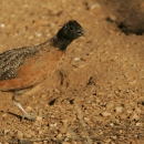
The Buenos Aires National Wildlife Refuge (BANWR) is in the Altar Valley of Southeast Arizona. BANWR has employed prescribed fire for over three decades to reintroduce historic fire regimes, reduce woody species encroachment, and enhance productivity of native semidesert plants. Vegetation monitoring efforts began in 2013 to assess the response of plant communities to the Multi-Unit Burn Plan using modern fire and habitat monitoring tools important to improving recovery for the critically endangered masked bobwhite quail for which the refuge was created in 1985.
Prior to refuge establishment in 1985, the Buenos Aires Ranch was a livestock operation managed by the Victorio Land and Cattle Company. Historic grazing and land use practices, combined with prolonged drought periods, have contributed to conditions on the refuge today. Prior to the expansion of livestock grazing in southern Arizona at the turn of the century, the Altar Valley was dominated by expanses of native semidesert grassland with heterogeneous vegetation required to support a population of masked bobwhite quail. Wild populations of masked bobwhite quail have not been observed in Arizona since the early 1900s, but a captive breeding population has been maintained for reintroductions at BANWR since the 1970s. Today’s conditions likely differ dramatically because of the long-term grazing history, cessation of frequent fire characteristic of semidesert grasslands and introduction of nonnative perennial grasses. These factors have also contributed to the expansion of mesquite shrublands and deeply incised gullies changing water runoff patterns and desert hydrology.
Lehmann lovegrass (Eragrostis lehmanniana), a nonnative perennial grass species, was intensively seeded for forage in some of the northern portions of Buenos Aires by ranch managers during the 1970s. Precipitation patterns did not favor widespread establishment of the species until the 1980s and it has since become dominant over large expanses of the refuge. Lehmann lovegrass is now particularly abundant south of the headquarters where it was not historically seeded, but soil and precipitation conditions are more favorable. The areas south of headquarters are also some of the most frequently burned. Interannual climate variation, fire and site suitability appear to have led to the preponderance of Lehmann lovegrass on the south portion of BANWR. Lehmann lovegrass often creates near monocultures that reduce native plant diversity, and habitat and forage quality throughout southern Arizona grassland ecosystems. Additionally, it can produce up to four times as much biomass as native species, forming a more continuous fuel bed that changes fire behavior and vegetation successional patterns.
Key Issues Addressed
Monitoring is a key step in adaptive management. BANWR has successfully implemented a prescribed fire program for several decades. However, little monitoring has been done at scales that sufficiently sample refuge-wide variability to assess efficacy of fire prescriptions in accomplishing intended goals. Objectives of prescribed fire at BANWR are to address ecological effects of fire suppression such as the large increase of mesquite tree cover in grassland ecosystems since Anglo-American settlement. Introduction of invasive perennial grasses has greatly altered plant community composition and fire effects. The monitoring effort at BANWR seeks to use modern field and remote-sensing methods to inform fire management and the masked bobwhite quail recovery program.
Project Goals
- Compare fire management histories with vegetation field plots to assess masked bobwhite habitat conditions
- Improve field methods for monitoring fine-fuel loads, vegetation composition and structure structure
Something temporarily or permanently constructed, built, or placed; and constructed of natural or manufactured parts including, but not limited to, a building, shed, cabin, porch, bridge, walkway, stair steps, sign, landing, platform, dock, rack, fence, telecommunication device, antennae, fish cleaning table, satellite dish/mount, or well head.
Learn more about structure in semidesert grasslands - Examine how a range of biotic and abiotic factors contribute to habitat conditions in addition to fire application
Project Highlights
Adaptive Management: Refuge managers are incorporating vegetation monitoring results into alternative habitat improvement efforts, including creating mesquite brush piles that provide cover for quail and other small wildlife species.
- Capturing variability: Over 400 plots have been sampled that represent the spectrum of biophysical conditions at the refuge spanning all management units with known fire frequency histories.
- Landscape-Scale Models: Field data has been integrated with remotely-sensed satellite imagery to populate spatial models to estimate conditions within unsampled areas at a landscape scale. Spatial models were used to predict vegetation classes, fine-fuel biomass, and percent cover for woody and herbaceous plants and bare ground.
- New Technologies: This project tested the use of a field ceptometer that measures photosynthetically active radiation (PAR) intercepted by plants. It estimates plant leaf area index (LAI) for predicting fine-fuel biomass and fuel loads more efficiently than destructive sampling, allowing for larger sample sizes.
Lessons Learned

- There is a clear need for repeated long-term sampling to determine how variability in climate and precipitation patterns interplay with management actions to affect the vegetation and fuel characteristics.
- Prescribed fire has not achieved the desired result of enhancing native vegetation characteristics for masked bobwhite. Instead,nonnative plants are now more dominant, desirable shrub cover has been reduced, and mesquite encroachment has only been reduced in the highest burn frequencies where Lehmann lovegrass dominates. Consistent burning appears to eliminate a variety of shrubs and subshrubs that would provide both cover and food for masked bobwhite quail such as Acacia angustissima, A. gregii (syn. Senegalia gregii), Atriplex spp., Mimosa spp., Ziziphus obtusifolia, Calliandra eriophylla and others. Plots within the designated masked bobwhite zone and extended zone on the refuge showed very little shrub cover at <1% on average.
- A north-south climatic gradient shapes plant communities across the refuge and influences distribution of invasive Lehmann lovegrass--the wetter, southern portion of the refuge is more infested than the drier, northern extent.
- Drainages currently contain the best habitat for masked bobwhite quail. This could be related to fire exclusion, higher soil-moisture availability, and increased plant diversity and habitat heterogeneity.
Next Steps
- Encourage implementation of short- and long-term vegetation monitoring program to help assess and guide future management activities
- Identify additional treatments to promote native plant species and structural conditions on priority sites for quail habitat improvement and reintroductions
- Develop and use rapid habitat assessment techniques to inform refuge-wide suitability modeling for masked bobwhite quail
Funding Partners
Resources
- Plight of the Masked Bobwhite Story Map by Holly Eagleston
- Interim Performance Report: Determining prescribed fire and fuel treatment compatibility with semidesert grassland habitat rehabilitation for the critically endangered masked bobwhite quail (Colinus virginianus ridgwayi), 2016
- Masked Bobwhite: 5-Year Review USFWS 2014
- FWS Buenos Aires National Wildlife Refuge webpage
- Sesnie, S.E. et al. (2022). “Multisensor models for assessing recurrent fire compatibility with habitat recovery for a critically endangered species.” Remote Sensing of Environment 269.
Contact
- Steve Sesnie: Spatial Ecologist, USFWS Southwest Region, steve_sesnie@fws.gov
Case Study Lead Author
- Ashlee Simpson, CART Graduate Research Assistant, University of Arizona
Suggested Citation
Simpson, A. C. (2018). “Determining Prescribed Fire Compatibility with Masked Bobwhite Quail Habitat Rehabilitation.” CART. Retrieved from https://www.fws.gov/project/prescribed-fire-and-quail-habitat-rehabilitation.