Location
States
ArizonaEcosystem
DesertIntroduction
Climate change is increasing drought frequency and extreme heat in southwestern deserts, limiting water and impacting wildlife. Water scarcity in these regions is expected to worsen as deserts are predicted to experience a 20% decline in precipitation, a 400% increase in the number of extreme heat days, and an increase of 4 to 9° F in average temperature before the end of the century (Drake et al., 2015).
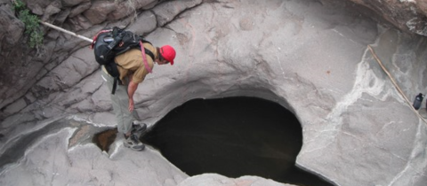
Most water naturally available for wildlife on the Barry M. Goldwater Air Force Range East , an arid part of the Sonoran Desert in southwestern Arizona, is located in isolated, temporary pools formed in rock (tinajas) and soil (charcos) that fill during rain events. However, as drought and heat waves exacerbated by climate change climate change
Climate change includes both global warming driven by human-induced emissions of greenhouse gases and the resulting large-scale shifts in weather patterns. Though there have been previous periods of climatic change, since the mid-20th century humans have had an unprecedented impact on Earth's climate system and caused change on a global scale.
Learn more about climate change speed evaporation, the quantity, duration, and quality of water in these isolated sites is declining, harming wildlife dependent on these resources (Griffis-Kyle, 2016).
While the U.S. Department of Defense primarily manages the range for military activities, they are also concerned with the conservation of vulnerable species threatened by the impacts of drought on water supplies. Because drought and extreme heat reduce water availability in tinajas and charcos for wildlife, managers must locate these aquatic resources to conserve the quantity and duration of water present.
In 2010, the U.S. Department of Defense contracted a research team from Texas Tech University (TTU) to inventory all known aquatic resources within the range and monitor the quantity and duration of water available for wildlife. Researchers at TTU, in collaboration with Jenness Enterprises, developed a model to predict the locations of landscape features capable of retaining water to create a more complete inventory of charcos and tinajas. The locations of charcos and tinajas can inform wildlife management of where to place artificial catchments to support wildlife.
Key Issues Addressed
Tinajas and charcos are important for wildlife but are difficult to locate via ground searches due to the vastness of the terrain and lack of vehicle access to most of the Sonoran Desert. Additionally, they are ephemeral, generally lasting for relatively short periods of time. They are small and often indistinguishable from the rest of the terrain when dry, and they are often hidden by the terrain when wet. The ambiguity of the locations of charcos and tinajas is a problem for wildlife management because the conservation of desert wildlife depends on the comprehensive knowledge of the locations of available water.
Many species of wildlife are reliant on charcos and tinajas for hydration, including the endangered Sonoran pronghorn (Antilocapra americana sonoriensis), migrating and resident birds, and many amphibians and insects. Some wildlife with complex life cycles, such as amphibians or some invertebrates, are even more reliant on tinajas and charcos as they require water for both hydration and breeding, early development, and temperature regulation. For example, shorter periods of water availability can cause catastrophic losses of entire cohorts of tadpoles if the sites dry before the amphibians can achieve metamorphosis. With less precipitation, tinajas and charcos become shallower and only available for short periods of time making them unavailable for wildlife during much of the year.
Project Goals
- Create a model to predict the location of isolated water features in the Sonoran Desert using GIS analysis of topographic features that retain water within the study site
- Search the predicted locations for water and quantify model accuracy
- Create a process that increases efficiency by reducing the effort, time, and money required to locate water resources
Project Highlights
- Predicting Water Location: Researchers used Mahalanobis Distance Analysis of landscape features conducive to the formation of charcos and tinajas to locate potential aquatic resources. The landscape variables examined in GIS software were Topographic Wetness Index (TWI) values, slope, and curvature. For example, an area is more likely to retain water if the slope is gentle or flat, if the slope is decreasing, and/or if the land is located within the drainage path of a large watershed. The model resulted in a list of sites more likely to contain aquatic resources than the surrounding terrain.
- Testing Model Accuracy:Researchers physically visited computer-generated random sites in addition to the model-chosen sites to determine if the model could locate aquatic resources more accurately than random searches. Researchers recorded both the coordinates of sites with tinajas and charcos, as well as chosen sites that did not contain aquatic resources to measure the accuracy of the model. Researchers also measured the quantity of any water found as another metric of the model’s usefulness for wildlife management.
- Wildlife Management Tool: The model correctly located water with 60% accuracy, a 30% improvement from random searches. Furthermore, the model-chosen sites contained twice as much water as the generated random sites. These results indicate that wildlife management can use the model in arid regions to locate aquatic resources as an important step in species conservation. Wildlife managers are also more likely to find larger quantities of water present using the model compared to random ground searches, enhancing their ability to steward the larger tinajas and charcos that are more important for wildlife conservation.
- Streamlined Ground Searches: Using the model as a tool to locate water can significantly reduce the time and labor necessary in performing random ground searches. While management will still have to travel to the site for water monitoring, they will no longer have to “comb the desert” to do so.
- Sonoran Pronghorn Recovery: Arizona Game and Fish Department used the updated inventory of charcos and tinajas to strategically place artificial catchments to support the Sonoran Pronghorn Recovery Team. The knowledge of the location of available wildlife waters was instrumental to placing catchments in areas to maximize Sonoran pronghorn population connectivity.
Lessons Learned

Water for All: Wildlife cameras captured a diversity of wildlife using tinajas within the study site, including mountain lions, bobcats, javelina, mule deer, pronghorn, raptors, and even a gila monster.
While the model was successful at predicting the location of isolated waters, there are several ways to improve the model. Wildlife managers should use caution when using TWI in arid environments because TWI was created in a more temperate climate. TWI values are largely based on the size of the watershed to predict the accumulation of surface water. In xeric landscapes such as the Sonoran Desert, there may be extremely large watersheds but hardly any rain, which can result in misleading TWI values. To compensate for misleading values, managers can use climate as a variable in the Mahalanobis Distance Analysis, such as PRISM data overseen by Oregon State University.
Normalized Difference Water Index (NDWI) values can also be used as inputs in the analysis to locate aquatic resources. NDWI values are captured using high resolution satellite imagery with a green color band filter to capture standing water. However, there is no vegetation that can indicate tinajas, while tinajas’ small size and ephemeral duration prevent their adequate representation in satellite imagery. The team designed the model without NDWI and NDVI for the values’ setbacks in this context.
Similar analyses can be performed in different landscapes to assist managers with other natural resources and wildlife issues, such as locating suitable habitat for wildlife. Many landscape variables of importance to wildlife, such as precipitation, elevation, and vegetation densities, can be used in Mahalanobis Distance Analysis. This means similar modeling can be performed to predict species distribution, gene flow, and the potential spread of invasive species invasive species
An invasive species is any plant or animal that has spread or been introduced into a new area where they are, or could, cause harm to the environment, economy, or human, animal, or plant health. Their unwelcome presence can destroy ecosystems and cost millions of dollars.
Learn more about invasive species .
Next Steps
- Expand use of model to the entire military base to create a more comprehensive inventory of aquatic resources
- Include water quality monitoring in the inventory and observation of tinajas and charcos. Because the study site is located where military tests and exercises are performed, the level of toxins in the water and wildlife disease in desert waters is of particular importance to monitoring efforts.
- Include model data in landscape connectivity analyses to reflect aquatic resources large enough to support wildlife
Funding Partners
Luke Air Force Base 56th Range Management Office
Resources
- Colorado State University Center for Environmental Management of Military Lands. (2018). Barry M. Goldwater Range Integrated Natural Resources Management Plan 2018 update.
- Drake et al. (2015). “Testing a model for the prediction of isolated waters in the Sonoran Desert.”Journal of Arid Environments 118: 1-8.
- Griffis-Kyle et al. (2014). “Water Quality: A hidden danger in anthropogenic desert catchments.” Wildlife Society Bulletin 38(1): 148-151.
- Griffis-Kyle K. (2016). “Physiology and ecology to inform climate adaptation strategies for desert amphibians.” Herpetological Conservation and Biology 11:563-582.
- McIntyre et al. (2016). “A connectivity and wildlife management conflict in isolated desert waters”. Journal of Wildlife Management 80(4):655-666.
- Mahalanobis Distance Analysis
- Topographic Wetness Index
- Luke Air Force Base 56th Range Management Office
Contacts
- Kerry Griffis-Kyle, Texas Tech University: Kerry.Griffis-Kyle@ttu.edu
- Jeff Jenness, Jenness Enterprise: jeffj@jennessent.com
CART Lead Author
Jackelyn Alessi, Case Study Author, Southwest Drought Learning Network: jackelyn.alessi@gmail.com
The DLN is a peer-to-peer knowledge exchange between climate service providers and resource managers, created to gather and share lessons learned from drought events to prepare for future events. The DLN partners with CART to develop Case Studies, with funding from the National Drought Mitigation Center for interns and coordination support from the USDA Southwest Climate Hub.
Suggested Citation
Alessi, J. (2023). “Testing a Model for the Prediction of Isolated Waters in the Sonoran Desert.” CART. Retrieved from https://www.fws.gov/project/locating-isolated-waters-sonoran-desert.