
Location
States
ArizonaIntroduction
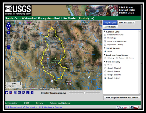
The Santa Cruz Watershed (SCW) is located in the Arizona-Sonora portion of the US-Mexico border. In 2010, researchers with the USGS and the EPA began an effort to create a map-based multicriteria evaluation tool for ecosystem services in the SCW. The Santa Cruz Watershed Ecosystem Portfolio Model (SCWEPM) incorporates a series of submodels about biophysical and socioeconomic factors that can be used across jurisdictions to visualize impacts in shared watersheds with a diverse group of stakeholders and inform adaptive management of resources.
Key Issues Addressed
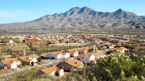
Urban expansion, intensified agriculture, resource extraction, and over-allocated water resources have impacted the people, economy, and natural resources of the SCW significantly. These land cover changes have led to habitat fragmentation and impaired ecosystem integrity, directly driving changes in ecosystem services. Ecosystem services are benefits provided by nature that benefit households, communities, and economies. Changes in climate and land use patterns will continue to impact ecosystem services. Assessing future impacts to ecosystem services in the Santa Cruz Watershed is essential to making informed land-use planning and policy decisions.
Project Goals
- Work with stakeholders to identify ecosystem services that contribute to physical, biological, and social qualities and resilience of the SCW
- Develop interacting submodels with natural and social scientific information in a framework that recognizes a diversity of values
- Integrate submodels into SCWEPM to demonstrate the effect of land-use and climate changes on ecosystem services that can be used to support decision-making and management objectives
Project Highlights
- Stakeholder Engagement: At the onset of SCWEPM planning, an interdisciplinary, multi-agency team of stakeholders developed a research question to focus project development.
- Ecosystem Service Value Maps: Maps are generated by the SCWEPM as a result of interacting submodels and user-specified weighted values for environmental criteria. These models can be run under a suite of climate and population change and impact scenarios to show how changes in land cover will affect ecosystem services over time.
- Dynamically Interacting Submodels: There are three submodels within the SCWEPM, each with various subsets of input data. The Ecological Value Submodel includes water, vegetation, and habitat provisioning; the Human Well-being Submodel includes socio-environmental vulnerabilities based on population characteristics (social and demographic), urban characteristics (access to basic infrastructure), and household assets (income); and the Market Land-Price Submodel includes real estate values and a willingness to pay index.
- Application to Inform International Policy: The SCWEPM can help provide a scientific rationale to inform international water management decisions. For example, the EPM was used to run five different scenarios for surface water flow as a result of effluent discharge from the Nogales International Wastewater Treatment Plant. Results suggested that policies to maintain the riparian riparian
Definition of riparian habitat or riparian areas.
Learn more about riparian corridor via managed effluent for instream flows can support biodiversity and provide economic benefits to homeowners in Santa Cruz County, improving regional economics and quality of life. - Linkages with Human Well-being: the SCWEPM acknowledges the link between environmental quality and human well-being components including human health, environmental justice, and quality of life. For example, the model could allow users to investigate the association between air pollution and aeroallergens with respiratory diseases (e.g., asthma) or changes in water resources and vector-borne diseases (e.g., malaria, dengue, encephalitis, hantavirus, or Rift Valley Fever).
- Environmental Justice: the SCWEPM incorporates explicit consideration of the distribution of impacts in ecosystem services management among across international boundaries and among neighborhoods with disparate income levels. Researchers developed a Modified Socio-Environmental Vulnerability Index (M-SEVI), using binational census and neighborhood data that describe levels of education, access to resources, migratory status, housing, and number of dependents, to provide a simplified snapshot of the region’s populace that can be used in binational planning efforts to compare the distribution of environmental hazards. The goal of this is to help decision makers identify communities in need of assistance, with metrics to support them.
- Ecosystem Services Affect Real Estate Value: Researchers used the hedonic pricing method which examines characteristics that determine value to measure the effects of vegetation and land cover, land administration, measures of species richness and open space, and proximity to amenities on real estate values. finding that policies to maintain biodiversity and open space provide economic benefits to homeowners.
Lessons Learned
Visualizing Impacts: The SCWEPM allows users to visualize impacts of natural phenomena and management practices in reference to the location of cultural resources, scenic attractions, water availability, and natural areas.
- The aggregation of data across jurisdictional and international boundaries is especially difficult when there are multiple resolutions and classification schemes, not to mention languages.
- This transboundary nature of this project required an understanding of cultural differences to avoid miscommunication and misunderstanding. Especially in regards to increasingly controversial subjects like water management in arid lands, using an ecosystem services approach to examine ecological, economic, and societal effects on human well-being can encourage cross-culture collaboration. It is hoped that continued advancement of interdisciplinary ecosystem service investigations can establish a precedent for binational policy development and implementation.
- Further improvements to the SCWEPM should incorporate measures of environmental quality and human health, specifically to examine if people living in socio-environmentally vulnerable neighborhoods were impacted by their lack of access to ecosystem services
Next Steps
- Use ecosystem service quantification information from SCWEPM to motivate policy decisions regarding management of water resources, quality of life, real estate, and habitat availability
- Further examine agricultural and eco-tourism dollars to better inform the cost-benefit analysis of some of the other ecosystem services findings (water provisioning, etc.)
Funding Partners
- USGS Land Change Science (LCS) Program
- EPA: Ecosystem Services Research Program (ESRP) and Southwest Ecosystem Services Project (SwESP)
- USGS: Geographic Analysis and Monitoring (GAM) Program and U.S.-Mexico Border Environmental Health Initiative (BEHI)
Resources
- USGS Website: Ecosystem Services Analysis of Climate Change and Urban Growth in the Upper Santa Cruz Watershed; the Santa Cruz Watershed Ecosystem Portfolio Model (SCWEPM)
- Norman, L., et al. (2013). “Framing Scenarios of Binational Water Policy with a Tool to Visualize, Quantify and Valuate Changes in Ecosystem Services.” Water 5(3): 852–74. doi:10.3390/w5030852.
- Niraula, R., et al. (2012). “Multi-gauge Calibration for Modeling the Semi-Arid Santa Cruz Watershed in Arizona-Mexico Border Area Using SWAT.” Air, Soil and Water Research 5 : 41. doi:10.4137/ASWR.S9410.
- Norman, L.M., et al. (2012). “Socio-Environmental Health Analysis in Nogales, Sonora, Mexico.” Water Quality, Exposure and Health. doi:10.1007/s12403-012-0067-x.
- Norman, L.M., et al. (2012). “Developing Spatially Explicit Footprints of Plausible Land-use Scenarios in the Santa Cruz Watershed, Arizona and Sonora.” Landscape and Urban Planning 107(3): 225–35. doi:10.1016/j.landurbplan.2012.06.015.
- Norman, L.M., et al..(2012). “Mapping Socio-environmentally Vulnerable Populations Access and Exposure to Ecosystem Services at the U.S.–Mexico Borderlands.” Applied Geography 34: 413–24. doi:10.1016/j.apgeog.2012.01.006.
- Norman, L.M., and Labiosa, B. (2012). “The Santa Cruz Watershed Ecosystem Portfolio Model (SCWEPM); Progress and Future.” In Proceedings of Santa Cruz River Researcher’s Day, March 29, 2012, Tucson, Arizona.
- Norman, L.M., et al. (2010). “Ecosystem Services: the SCWEPM Bridge across Transboundary and Environmental Justice Divides.” ACES, A Conference on Ecosystem Services, Dec., 2010, Phoenix, AZ.
- Villarreal, M.L., et al. (2013). “Biodiversity Losses and Conservation Trade-offs: Assessing Future Urban Growth Scenarios for a North American Trade Corridor.” International Journal of Biodiversity Science, Ecosystem Services & Management 9(2): 90–103. doi:10.1080/21513732.2013.770800.
Contact
- Laura Norman, Research Physical Scientist, USGS, lnorman@usgs.gov
Case Study Lead Author
- Ashlee Simpson, CART Graduate Research Assistant, University of Arizona
Suggested Citation
Simpson, A. C. (2018). “Climate and Land Cover Change Ecosystem Services Analysis: The Santa Cruz Watershed Ecosystem Portfolio Model.” CART. Retrieved from https://www.fws.gov/project/climate-and-land-cover-santa-cruz-watershed.
