
Location
States
ArizonaIntroduction
The Las Cienegas National Conservation Area (LCNCA), managed by the Bureau of Land Management (BLM) and located about 50 miles (80 km) southeast of Tucson, is well-known for its exceptional biological value, including five of the rarest community types in the American Southwest. Since 2007, the BLM has been combating shrub species encroachment at LCNCA with the goal of treating about 21,000 acres. The BLM has partnered with The Nature Conservancy (TNC) to evaluate the effectiveness of a suite of brush treatment techniques through rigorous monitoring.
The LCNCA is home to six federally listed species, is on the National Register of Historic Places, and has two proposed wild and scenic river segments. Its exceptional biological, cultural, and scenic values make it a local, regional, and national priority for the BLM as well as for other organizations and public agencies. In an analysis of 600 conservation areas identified in the five eco-regions overlapping Arizona, the conservation area conservation area
A conservation area or wildlife management area is a type of national wildlife refuge that consists primarily or entirely of conservation easements on private lands. These conservation easements support private landowner efforts to protect important habitat for fish and wildlife. There are 15 conservation areas and nine wildlife management areas in the National Wildlife Refuge System.
Learn more about conservation area that includes LCNCA ranked highest in terms of biological uniqueness and irreplaceability.
In 2004, the BLM entered into a cooperative agreement with TNC to evaluate the current status and condition of resources on LCNCA and to review its existing monitoring protocols. This ongoing collaboration has expanded to encompass other endeavors of mutual interest including ecological state and distribution mapping of sacaton riparian riparian
Definition of riparian habitat or riparian areas.
Learn more about riparian grasslands; monitoring grassland condition and trend; and evaluation of the effectiveness of this brush treatment and grassland restoration program.
Key Issues Addressed
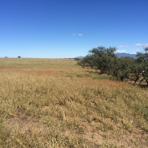
In western North America, woody species encroachment on grasslands is driven by historic overgrazing and fire suppression. As a result, accelerated erosion and loss of perennial grass cover has led to reduced forage for livestock and diminished habitat for grassland-dependent wildlife species. A native woody species, velvet mesquite (Prosopis velutina), now dominates vast areas that were once semi-desert grasslands at LCNCA. Many regional land managers are engaged in brush treatment techniques to control mesquite and other woody species; however, the effects of most treatment efforts have been poorly documented. There is a strong need to determine effective and ineffective brush treatment techniques in the context of an adaptive management program.
Project Goals
- Reduce velvet mesquite cover to maintain semi-desert grasslands for wildlife, livestock, and decrease erosion
- Employ pre- and post-treatment monitoring to assess treatment effectiveness and impacts
- Incorporate results into adaptive management strategy
Project Highlights
- Defining Targets: Desired brush treatment outcomes were specifically defined and included:
- Reducing woody plant cover to 5%, a value identified as critical for fawning habitat for pronghorn
- Maintaining basal cover of perennial grasses above 8% and bare ground cover below 30% based on ecological site descriptions
- Establishing a 5% minimum basal cover of perennial grasses as a threshold for triggering management action by the BLM since grasslands falling below this mark are vulnerable to shrub encroachment and accelerated soil erosion
- Site Selection: The treatment area was strategically chosen because it will connect grasslands already in good condition and contains few obstacles to heavy equipment. The area also has a high concentration of sites with high visitor use, designated recreation, and protected historic sites. Project partners chose to focus treatments on grasslands with the highest woody cover (and greatest risk of conversion to scrubland) and work progressively southward to connect with open grasslands.
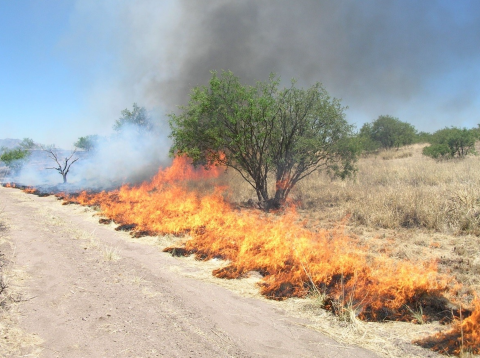
- Brush Treatments: Six treatment combinations have been implemented to control woody species:
- Fire- apply controlled application of fire.
- Mechanical Grub- mechanically remove tree and root crown out of the ground using heavy equipment.
- Masticate + Stump Spray*- mechanically shred trees at ground level and treat the stump with herbicide((Pathfinder II at 0.45 lb active ingredient at 30 gal/ac).
- Cut + Spray*- cut trees with chainsaws at ground level, treat the stump with herbicide ((Pathfinder II at 0.45 lb active ingredient at 30 gal/ac).
- Foliar Spray*- apply herbicide (Remedy 0.60 acid equivalent (AE)/ac + Reclaim (0.45 AE/ac)+ Activator 90 + Blue Turf Dye at 30 gal/ac) to canopy of mesquite trees
- Masticate + Spray* + Fire- Mechanically shred trees at ground level and treatment the stump with herbicide, followed up with a prescribed fire treatment.
* Spray= herbicide treatment applied with backpack sprayer
- Large-Scale Treatment: As of June 2018, Over 15,000 acres have been treated:
- Chemical (includes cut+spray, mastication+spray, & foliar spray)- 1,615 acres
- Fire- 9,827 acres
- Mechanical- 5,134 acres
- Pre and Post-treatment Monitoring: To quantify the effects on mesquite and track grassland response across treatment areas, TNC and BLM staff established permanently marked 50-meter transects at stratified, random locations. Detailed monitoring protocols are included in the final report (see resources). The transect measurements included:
- Line-Intercept- measured canopy cover and maximum height of all woody species where they intersect the transect line
- Belt Transect- measured density, height, and in some cases canopy dimensions and canopy dieback, of woody and succulent species within 2m of the transect
- Point-Intercept- recorded aerial and basal cover of all vegetation and substrates every 0.5 meters.
- Point-Centered Quarter- quantified the density of woody species by size/height class.
- Repeat Photography- documented pre- and post-treatment visuals.
Lessons Learned
- Non-fire treatments dramatically reduced the cover of mesquite with mechanical grubbing and cut + spray having the most pronounced effects. Treatment effects are summarized below:
- Fire- variable effectiveness with substantial between-plot variation obscuring potential treatment effects. As these sites are re-burned, further effects of fire on woody species cover may be realized.
- Mechanical Grub- highly effective at killing mesquite (91% mortality) with only 9% of grubbed plants resprouting (n = 110 individuals). Resprouting only occurred with mesquite less than 2 m height; all tree-size mesquite were killed by this treatment.The ability of an operator to severe the tap and lateral roots of mesquite is paramount to the success of this treatment.
- Masticate + Stump Spray- short effective life span due to extensive basal resprouting following treatment and low mesquite mortality at 20%.
- Cut + Spray- most effective (81% mortality) when the stems were cut flush with the ground compared to when stumps were cut above the ground (27% mortality).
- Foliar Spray- killed about 40% of treated mesquite, with higher mortality for mesquite less than 2 meters tall.
- Masticate + Spray + Fire- the addition of fire increased mortality 15% (to 35%) compared to mastication and spraying (20% mortality).
- All treatments generally resulted in increased perennial ground cover and reduced bare ground the first or second year after treatment, indicating increasingly healthy grassland.
- The least expensive treatment, prescribed fire, provides the smallest reduction in woody plant cover – at least with one burn. Cut + spray was the most expensive treatment, but was the most effective in providing immediate reductions in plant cover when best practices were used (cutting stumps flush with the ground). Mechanical grubbing, intermediate in cost and best at effectively reducing mesquite cover, provides the best all-around cost-effectiveness.
- Retreatment strategies should be an integral part of any treatment plan. Sustaining successful management strategies will require long-term commitment to monitoring and a mechanism for continued funding.
Next Steps
Adaptive Management: Monitoring results are being used to inform future treatment planning, providing the basis to modify current management strategies.
- Develop and implement a maintenance program to keep previously treated areas from re-establishment of mesquite
- Continue to work with partners to develop priority treatment areas based on grassland restoration objectives and wildlife habitat (prairie dog, antelope, birds) objectives, to include habitat expansion and creating connectivity corridors
- Continue to plan and implement grassland restoration treatments not only on BLM-managed lands, but also in coordination with adjacent landowners (state, private, county, federal)
- Continue to implement a wood permit program with local public, organizations, companies, tribes to utilize wood products (firewood, millwood) generated during thinning treatments
- Continue to work with partners to monitor vegetation treatment effects and work towards developing other tools such as remote sensing GIS mapping to spatially show where the grassland treatments are meeting objectives, identify priority treatments, areas, etc.
- Update the National Environmental Policy Act (NEPA) analysis for LCNCA to incorporate lessons learned in the past ten years of treatments to update and refine the approach to restoring grasslands
Funding Partners
- National Fish and Wildlife Foundation: Sky Islands Grassland Initiative
- Pima County
- Bureau of Land Management
- American Recovery and Reinvestment Act of 2009
Resources
- R. Tiller, D. Quintana, G. Bodner, and K. Simms, 2012. “Semi-desert grassland restoration in the Sky Island Region: Effectiveness of brush treatments and grassland response.” Final report prepared for the National Fish and Wildlife Foundation. Tucson, AZ. 53 pp + appendices.
- Las Cienegas National Conservation Area BLM webpage
- Historic American Landscapes Survey: Empire Ranch Landscape
Contacts
- Dan Quintana, Fuels Program Manager, BLM Gila District, dquintan@blm.gov
- Gita Bodner, Conservation Ecologist, The Nature Conservancy, gbodner@tnc.org
Case Study Lead Author
- Ashlee Simpson, CART Graduate Research Assistant, University of Arizona
Suggested Citation
Simpson, A. C. (2018). “Brush Treatment for Grassland Restoration as Part of an Adaptive Management Framework in the Cienega Creek Watershed.” CART. Retrieved from https://www.fws.gov/project/bush-treatment-cienega-creek-watershed.
