
Written By

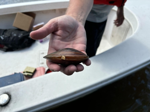
“Party Barge to Brian Watson. Party Barge to Brian Watson. We have a live ochracea for him to swab,” Bill Crouch said into the radio. Crouch, Deputy Refuge Manager for the Rappahannock National Wildlife Refuge, gripped the steering wheel of the roomy pontoon boat—the largest in a six-boat flotilla leapfrogging its way down the river. The boat had earned its name from the mini disco ball hanging above the wheel, but today, it was all business. A scratchy voice crackled back over the radio, “Hold onto it!”
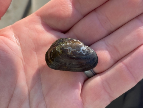
The team wasn’t out for a casual boat ride—these scientists and divers were on a mission to uncover hidden life beneath the surface. Freshwater mussels, often mistaken for ordinary rocks, are some of the most vital and at-risk animals in our rivers.
Searching for Mussels in the Murky Depths
On a sunny day in late August, biologists, boat captains and specialized technical divers from Florida to New York converged on the Rappahannock River near Fredericksburg, Virginia. Like many of the Atlantic’s coastal rivers, the Rappahannock is big, dark, and deep. It is nearly 200 miles long, up to a mile wide, and 50 to 80 feet deep in places. Below all that water, hidden from view, are some of the most important – and at risk – animals on the planet. Freshwater mussels.
Unlike their marine relatives, freshwater mussels aren’t sought after for food, but they play an even more crucial role in the ecosystem. They filter water, recycle nutrients, stabilize the riverbed, and provide habitat for other species. Where mussels thrive, the river supports more fish, more insects, and cleaner water.
Despite their benefits and importance, freshwater mussels are some of the most at-risk species on the planet. As the filtration system for the river, mussels are vulnerable to contaminants running from the landscape into the waterways, especially runoff chemicals and sedimentation from development that can smother the river bottoms.
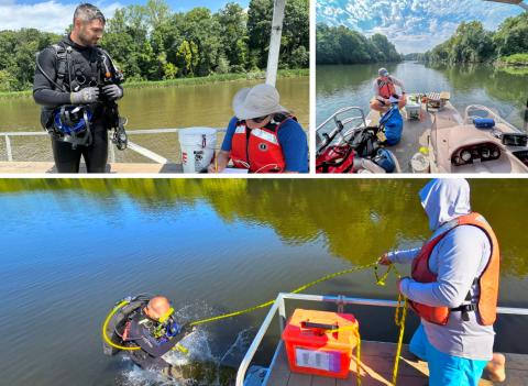
Protecting and restoring these important animals, and the free filtration services they provide, is a priority for everyone, but efforts are often held back by a simple lack of knowledge. A common need emerged among those working to protect mussels - an inventory of the mussels in Atlantic coastal rivers that could tell biologists where the mussels are, how many there are, and if they are reproducing. Answering these questions is easy in small streams or rivers, but in big coastal systems like the Rappahannock, it takes highly specialized and experienced divers, boat captains, and a whole team of experts – the Mussel Strike Team!
The Mussel Strike Team to the Rescue
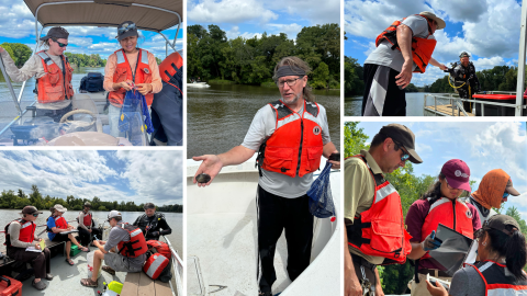
The Mussel Strike Team was conceived as a way to share resources to meet a common aim - to map the abundance and diversity of freshwater mussels in the Rappahannock River, and to be available for deployment to help our partners document the status of mussels in large rivers. The boats, captains, and divers had come from offices in Florida, Arkansas, North Carolina, Tennessee, West Virginia, Virginia, Maryland, and New York, and were led by experienced dive captain Channing St. Aubin. St. Aubin, who is based in Florida at the Panama Fish and Wildlife Conservation Office, had trained the divers on new specialized protocols for sampling mussels and new diving protocols for working in the large river. Brian Watson, Aquatic Resources Biologist with the Virginia Department of Wildlife Resources, led additional topside crew members in identifying freshwater mussels.
The plan was to sample 277 points from the fall line at Falmouth, Virginia, located just upstream of Fredericksburg. And downstream to where the water becomes brackish near Tappahannock, Virginia. Because that area had been surveyed very little in the past, this work would fill in a significant data gap for the Virginia DWR.
By the end of the week, the survey crews had sampled 188 transects, covering 47 river miles, and found six species, including the green floater, a candidate for federal listing as threatened, and the tidewater mucket, considered at-risk and a species of concern in many northeast states. The survey also identified where mussels are present in the river and their relative abundance, as well as what types of substrate habitats are being used by mussels. The survey stopped short of the original 277 points they planned to sample when they reached brackish water where freshwater mussels were no longer being found.
Beyond counting mussels, the survey also identified where mussels were most abundant and what types of riverbed habitats they preferred. The data will be sent to Teresa Newton Ph.D. at the U.S. Geological Survey’s Upper Midwest Science Center, where she will use it to estimate mussel population sizes and assess the vital ecosystem services they provide.
The data collected will be sent to Dr. Teresa Newton at the U.S. Geological Survey’s Upper Midwest Science Center. Dr. Newton, who designed the survey, will use the data to estimate the size of mussel populations and the ecosystem services they provide in the river.
This kind of large-scale mussel survey had never been conducted in the lower Rappahannock. The team’s work will provide a crucial baseline, helping scientists track changes in mussel populations over time and guiding future conservation efforts.
A Coordinated Effort
Pulling off a project of this scale wasn’t easy. “Coordinating a project of this size with a limited budget is a bit like organizing a bake sale,” said Catherine Gatenby, Ph.D., from the Lower Great Lakes Fish and Wildlife Conservation Office. “You ask all your friends for help. Someone brings the boats—six, to be exact. Someone else brings the captains—six of those, too, please. And then you need 80 collecting nets, 10 quarter-meter quadrats, some depth finders, coolers, calipers, navigation devices, divers, first mates, data collectors, and—please don’t forget—the port-a-johns. Then you pray the weather cooperates.”
Thanks to careful planning and dedicated teamwork, the survey was a resounding success. “There has never been a systematic survey of the lower Rappahannock River because of the difficulty in surveying a river that size and because SCUBA is needed,” said Watson. “This survey gave us a better idea of how mussels are distributed throughout the river and where they exist in greater abundances. We also gained valuable insight into the types of habitats these freshwater mussels seem to prefer. This information will help guide restoration efforts for freshwater mussels in the Rappahannock River.”

Looking Ahead
With the data in hand, the team packed up their boats, the mini disco ball on the Party Barge glinting in the late afternoon sun. It wasn’t just a successful survey—it was the start of a clearer picture of the river’s hidden world.
“Projects like this are why most of us got into this work. It’s about doing something that is meaningful, helpful to others, and that will have a positive impact on the environment, for people, and for the future,” said Gatenby.
Written By


